Background
IBML owns 46.3% of Omico Copper Limited based in Mauritius which in turn owns 95% of Craton Mining and Exploration (Pty) Ltd in Namibia. Craton maintains Mining Licence ML197 which covers the Omitiomire Copper project areas. Omico Copper Limited is fully funded and is committed to investing USD5.0 million in the production of a Bankable Feasibility Study (BFS) planned to be complete by calendar year end 2022. Omico also hold Exploration Licence EPL3589 covering 735km2 which can be broadly described as the ground surrounding the mining licence.
Drilling by the Company has identified a JORC Indicated and Inferred resource of 137 million tonnes (‘Mt’) of ore at 0.54% Cu for 740,000 t contained copper at a 0.25% Cu cut-off grade (Bloy, August 2014). On 24 December 2017, a Mining Licence (ML197) was granted by the Namibian Ministry of Mines & Energy for a perio
d of 20 years.
The Omitiomire Copper Project is located 140 km by road northeast of Windhoek in central Namibia, in semi-arid savannah-type grazing land.
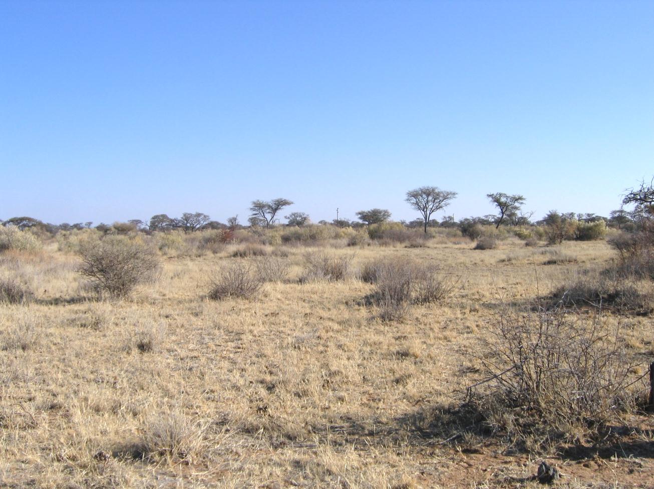
Omitiomire project area
Geology of the Omitiomire Deposit
Drilling has defined a broadly tabular copper deposit, striking north-south and dipping at a shallow angle (around 20°-30°) to the east. The deposit forms sub–outcrop, beneath shallow sand cover, over several hundred metres; at depth, drilling has shown a strike length of over 3,500 metres (‘m’). The deposit is about 10m thick near surface but thickens to the east, where some drill holes have intersected over 100m of copper mineralisation.
The deposit consists of a number of stacked parallel tabular bodies (“lenses”) which partly merge.
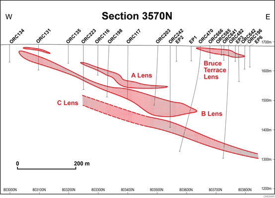
Drill section showing stacked ore lenses. The numbers on the right-hand side of the figure show elevation above sea level
In August 2014, Bloy Resource Evaluation (‘Bloy’) provided an updated resource estimate of 137 million tonnes (‘Mt’) at an average grade of 0.54% copper (‘Cu’) at a cut-off grade of 0.25% Cu. The resources are reported in accordance with the guidelines set out by the Joint Ore Reserves Committee (JORC, 2012). The Measured and Indicated categories constitute 71% of the deposit.
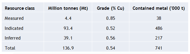
Table 2. Omitiomire resource at a cut-off grade of 0.25% Cu (Bloy, 2014).
Note: The resource figures are not constrained within any form of resource limiting pit shell
In addition, Bloy reported Exploration Target material, also at a cut-off grade of 0.25% Cu, in the range 76 Mt – 155 Mt for 430,000t – 650,000t of metal grading between 0.4% and 0.6% Cu.
Caution: Exploration Target material remains conceptual in nature and might or might not be realised in the future.
Note: The technical information relating to the Omitiomire resource has been summarised from a report, dated 31 August 2014, provided to Craton by Ms Carrie Nicholls and Mr Michael Rohwer of Bloy Resource Evaluation. Both Ms Nicholls and Mr Rohwer are Members of the Australasian Institute of Mining and Metallurgy and have sufficient experience to qualify as Competent Persons as defined in the September 2012 edition of the “Australasian Code for Reporting of Exploration Results, Mineral Resources and Ore Reserves”. Ms Nicholls and Mr Rohwer consent to the inclusion of the information in the form and context in which it appears.
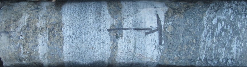
Primary copper mineralisation occurs mainly as the mineral chalcocite (Cu2S) with minor bornite (Cu5FeS4) within bands of mafic (amphibole-biotite-plagioclase) schist. There are no iron sulphides (pyrite or pyrrhotite). The highest copper grades are associated with bands of strongly-deformed epidote-biotite schist. Inter-banded felsic (quartz-plagioclase-biotite) gneiss is barren. Banding is on a scale of centimetres to metres in thickness.
Sawn NQ drill core showing the banded nature of Omitiomire ore.
The steel-grey mineral is chalcocite and the brown-coloured mineral is chrome-epidote
Primary sulphide copper is oxidised to 20m depth and partly oxidised to 40m depth. Oxide copper occurs mainly as the mineral malachite (green hydrated copper carbonate) with subordinate chrysocolla (blue hydrated copper silicate) and minor tenorite (black copper oxide). The proportion of primary chalcocite increases with depth.
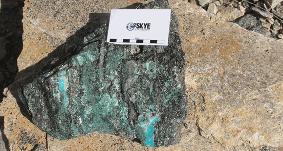
Omitiomire oxide copper ore. The green mineral is malachite; the blue-green mineral is chrysocolla
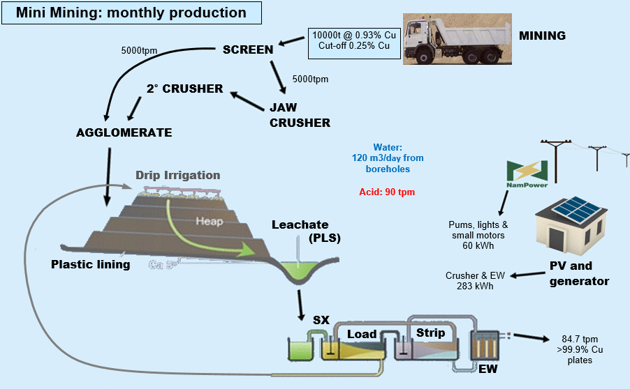
Omitiomire Copper Project - Mini Mining
Craton plans initial development of a small, shallow “Mini-Mining” operation, to bring the project into production quickly and at low cost. The “oxide copper” minerals are readily leached (dissolved) in dilute sulphuric acid, making the oxide zone amenable to treatment by acid leach – solvent extraction (‘SX’) – electro-winning (‘EW’) technology.
The plan involves mining a modest tonnage (10,000 tonnes per month - ‘tpm’) of oxide copper ore in a small open-cut mine to a depth of 16m. The ore grade, still to be confirmed by an external consultant, is estimated at 0.93% Cu. The mine will be designed to have minimum impact on existing infrastructure, particularly avoiding an existing public road.
The ore will be treated by heap leach - SX - EW to produce cathode copper. Extensive bench-scale tests show 89% leach recovery of copper, low acid consumption, and a final cathode copper product of about 99.99% Cu. Craton plans metallurgical testing on a bulk sample to ascertain the need for agglomeration and to confirm the bench-scale test results.
Proposed processing route for oxide copper ore
The financial model shows a maximum draw-down of about N$50 million, two months after production start-up and an undiscounted payback period of two years at US$ 2.50 /lb. These financials are indicative at this stage; some costs need to be confirmed in order to update the financial model.
The planned work program to commencement of production is:
- Complete the sale of a minority stake in Craton to approved Namibian group(s);
- Complete an access agreement with the farm Omitiomire;
- Collect a bulk sample and conduct metallurgical tests;
- Carry out external studies of the project including a review of the metallurgical process;
- Revise the capital & operating costs and finalise the financial model;
- Carry out detailed mine and process plant design;
- Proceed to construction.
Once access to the site and the sale of a minority stake in Craton is complete, the time to full production is expected to be 15 months.
Proposed Phase 2 Sulphide Copper Project
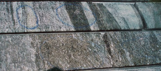
The banded orebody is amenable to simple beneficiation. Copper is concentrated in dark (mafic) bands whereas pale-coloured (felsic) bands are largely barren.
Drill core showing copper-bearing mafic bands and barren felsic bands
The copper-bearing mafic schist bands are soft and heavy whereas the barren felsic gneiss bands are hard and light. This difference in physical characteristics between copper-bearing and barren bands permits low-cost and effective pre-concentration by dense medium separation (‘DMS’). Testwork carried out at Mintek Laboratories near Johannesburg has shown that this process doubles the grade of mill feed to +1% Cu.
The main copper mineral, chalcocite, contains 79% Cu. Bench-scale metallurgical studies have shown 90% recovery from the sulphide zone, to produce a high grade (+50% Cu) concentrate with no deleterious elements such as arsenic and bismuth.
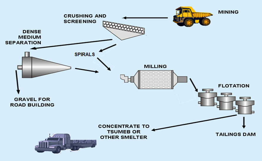
Phase 2 project: Proposed process flow chart
The PFS identified the following infrastructure requirements for the Phase 2 operation:
- A 90 km water pipeline to connect the project to the Namibian water supply network;
- A 115 km power line to connect the project to the Namibian power grid;
- Road upgrades either to transport copper concentrate to the existing railway at Nossob siding, or to connect to existing sealed roads to the port at Walvis Bay on the Atlantic coast;
- An on-site village to accommodate the workforce;
- A river diversion around the proposed open-cut mine.
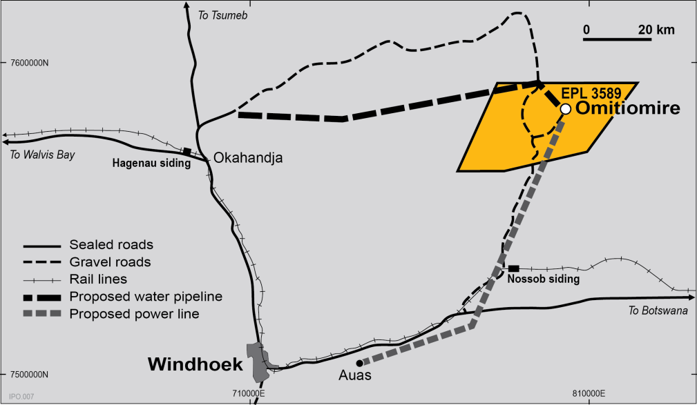
Infrastructure upgrades proposed for the Phase 2 operation (from 2010 PFS)
Craton intends to commence a Phase 2 Definitive Feasibility Study (‘DFS’) when the “Mini Mine” is in operation, providing cash flow for the study. It is anticipated that the larger project would be based on the deeper sulphide copper resource at Omitiomire plus other copper resources which might be discovered within trucking distance of Omitiomire. This project will require a separate SEIA and Environmental Management Plan.
Note: The technical information contained in this document was compiled by Dr Ken Maiden, a Director of International Base Metals Limited. Dr Maiden is a Member of the Australian Institute of Geoscientists and a Fellow of the Australasian Institute of Mining and Metallurgy. He has sufficient experience to qualify as a Competent Person as defined in the September 2012 edition of the “Australasian Code for Reporting of Exploration Results, Mineral Resources and Ore Reserves (the JORC Code)”. Dr Maiden consents to the inclusion of the matters in the form and context in which they appear.